Terrain Visualization of India using SRTM and Openstreetmap data

Made this in QGIS using data from NASA’s SRTM and Openstreetmap. I got inspired by a terrain visualization I saw while browsing /r/MapPorn on reddit.
Data layers used:
SRTM: 1km dem with a custom color map, 1km dem slope shading.
OSM: Roads (white), Railways (yellow), Water features, Cities and Towns.
Bangalore to Mumbai, 18 hours by bus and better than expected
If you are traveling between Bangalore and Mumbai, you should consider the bus a serious alternative to the train.
Since my SL class ticket on the Kurla express got charted as RAC, I figured I might as well spend a few bucks extra for bus ride, which in all respects would be better than sleeping in my pool of sweat on the floor of our trains. Its adventurous and all the first few times, but when your dreams are interrupted by that little cockroach that sneaked into your sleeping bag, you figure its time to try the other options.
I got to redbus to figure out my bus options, and was surprised that the VRL multi-axle AC Volvos are both Rs.200 cheaper than the 3AC fares and a whole 5 hours faster than the train. I figured the multi-axle bus would be a smooth ride on our upgraded NHDP highways, and I was not wrong.
Departed from Ananda Rao circle at 7pm and reached Sion at 1:30 pm the next day, right on schedule and no signs of fatigue. I had a fully reclining seat, good curtains, personal power outlet (which I did not use), working airconditioning and a comfy blanket that was fresh enough to dig into. As a bonus, a friendly co-passenger, buss attendants and a good choice of meal and toilet stops regularly enroute. If only VRL had such service across the country, I would gladly drop the railways out of my travel options till they fix their game.
Found it! my scholarship to the Wikimedia Hackathon in Amsterdam
I was really hoping to attend this year’s annual Wikimedia Hackathon, especially with all the growing interest in Wikidata and Openstreetmap, the two projects that has currently caught my fancy.
I have attended every WMF hackathon since the first one at Mumbai in 2011, and it has never disappointed. The quality of people, interactions and knowledge gained at these events have always been top notch and a lot of fun.
One of the wonderful things about the Wikipedia world is the support given to the volunteers from the different chapters and the parent Wikimedia Foundation to promote community growth and building awesome stuff that the whole world can use. I happened to chance upon the announcements for the travel and accommodation scholarships to attend the Amsterdam Hackathon on the wikitech-l mailing list and gave it a shot considering my contributions to open map data, Wikimedia commons, interaction design for Wikimedia projects and participation in previous WMF events.
I looked up my inbox yesterday to see if I had missed any update on the scholarship, and sure enough my scholarship acceptance mail was unread from 2nd April. Thank you Wikimedia Nederlands! It’s such surprises that makes one love contributing to open source.
Chennai Urban Area Landuse Map

One of the artifacts of my experiments with Tilemill and some data cleaning and reclassification I was doing on the Chennai Openstreetmap data.
Designing a multilingual bus information poster for Mumbai’s bus stops
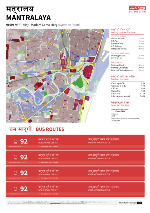
Draft design of an A3 poster that can be auto generated from data available from http://www.chalobest.in and openstreetmap, allowing users to print and paste it at their bus stops.
ISRO sees utility of openstreetmap data
While poking around Bhuvan – India’s hyped google earth competitor by ISRO, the country’s space agency, I happened to stumble upon a new WMS layer feature (link, see top right). Curious, i managed to extract the getcapabilities url using firebug (bhuvan wms getcapabilities) and used Qgis to connect to the server. The response had me pleasantly surprised.

The national highway and hospital data layers were actually made using openstreetmap data!To confirm, I compared the osm road vectors to the wms tiles and they match perfectly, and for many stretches osm now has more accurate data than what ISRO used when they created the layers.
Its strange that the national space agency would use data from the openstreetmap project rather than from the national mapping agency – Survey of India. Further proof that opengeodata is useful?
PS: The highlighted road is part of the Chennai port – Maduravoyal expressway under construction in Chennai. That road was marked by me and you would only find it in osm (link), nowhere else. The black lines are the roads from bhuvan.
Lessons from the New Tamil Nadu government text books

Woo! Found two of my photographs included in the new Tamil Nadu school geography textbooks. They have been conveniently taken from my uploads to wikipedia (click pic for details). Too bad that the usage is illegal though, as it breaks the cc-by-sa license and does not credit the author. Public school text books with unlicensed photographs from the internet, good job Government of Tamil Nadu (well, what do you know, the tidel park pic shows up on the TN govt website carousel as well) 🙂
I cant help but feel disappointed with quality of the textbooks, I guess thats the price you pay by cutting costs and doling out freebies.
+1
- Making the books accessible online in PDF format for free.
- Audio enabled textbooks for the visually impaired
-1
- Optimizing text for least size and not for interestingness. Make way for more kids who really dont know what they are learning and why.
- Poor choice of images, illustrations, typography and layout. Have any of these guys seen the quality of books elsewhere in the world?
- Lack of references or suggestions for further reading. If you cant explain a concept properly, atleast tell him where he can find a good explanation!
I feel sorry for the kids getting half baked education from these texts. It neither creates any interest in the subject nor promotes inquiry and discussion. It was for this reason that I hated school.
//
“Unless you do something, you wont become better at it” – Me
Enroute to Ladakh

My travel plan for the summer, from Coorg to Kashmir
After dillydallying between the Northeast, Utarranchal+Nepal and Sikkim+Bhutan, i finally decided on Ladakh. It was initially supposed to be just me and my two roomates from NID backpacking all the way, but seeing the lucrative destinations on offer, the gang has now grown to seven with two girls thrown in.
My initial budget estimate was 5k end to end, but now my roomate who is sitting in Delhi tells me he’s booked some super luxury volvo bus to manali costing a bomb. If things go this way, i dont think i’ll be left with anything to pay rent next month. Guess there wont be much backpacking after all 😐
The essential Chennai rail transport map – looking back
I have always been irritated by the transport services in India ever since i started living here from 2005, more because of the information blockage than the poor quality of the service itself. Atleast if somebody could tell me reliably that this is the route you had to take to get to your destination, thats half the pain gone. This was one of those factors which pushed me into this addiction of making urban transit maps for India, hardly anyone has attempted to make them, and the few attempts that were made looked like ass and was just as helpful to plan your trip.
Cutting a long (and interesting) story short, the chennai suburban rail map was my very first attempt at making a transit map. What i ended up creating was my best understanding of the info from the southern railway online suburban timetable. The weird division of the services managed to confuse me successfully which is quite evident in the end result. At this time i had still not used the trains in Chennai 🙂

My first rail map. Made in 2005 and can still be found on the IRFCA server
The accuracy didnt matter much, cause after posting it to a few places online, it became quite popular, for nobody had seen such a swanky looking map for a rail system in India. Its even been ripped off in numerous local publications. Something that came to my notice when i had met the PR head of the southern railways to explore the possibility of having schematic maps in the trains, and he told me these kind of maps were already done by somebody, promptly showing me a page from a local guidebook from his drawer. Not the first time i had somebody show me my own work, but i found it amusing nonetheless. Read More…
Hi
 PlaneMad's BitterScotch - A few photos, a little design, some unusual experiences and snippets of my college life in India more >


Moments captured


 feed me some bitterscotch
- Terrain Visualization of India using SRTM and Openstreetmap data
- Bangalore to Mumbai, 18 hours by bus and better than expected
- Found it! my scholarship to the Wikimedia Hackathon in Amsterdam
- Chennai Urban Area Landuse Map
- Designing a multilingual bus information poster for Mumbai’s bus stops
- ISRO sees utility of openstreetmap data
- Lessons from the New Tamil Nadu government text books
- //
- Enroute to Ladakh
- The essential Chennai rail transport map – looking back


Wall of Names